How Flood4Cast® works
Flood4Cast®converts radar-based nowcasts into actionable flood-risk forecasts and alerts — with the best available accuracy, updated every 5 minutes.
Where flood maps are available, an optional 20 m street-level depth layer shows expected water levels.
Optional sensor integration displays live rain and river readings alongside the forecast.
With operationally automated warning alerts, customized to your needs — what, when, how, and to whom.

Flood4Cast® in 7 steps:
1. Real-Time Rainfall Nowcasting
Flood4Cast® starts with real-time rainfall radar—the only observation that captures the spatial and temporal dynamics of convective storms at the scale needed for flash-flood warning. Its nowcasting projects rainfall up to three hours ahead and refreshes every five minutes, using the best available radar resolution (typically 500m–1km) to track fast-changing conditions.
")
Rainfall 11.25 (real-time)
")
Rainfall 11.55 (+30 min forecast)
")
Rainfall 12.25 (+60 min forecast)
2. Flood risk forecasting
Every 5 minutes, Flood4Cast® combines rainfall statistics with flood-susceptibility indices (e.g., imperviousness, runoff) to compute pluvial and fluvial flood risks. These risks are then aggregated across administrative areas relevant to your emergency planning and protocols.
")
Flood risks 11.25 (real-time)
")
Flood risks 11.55 (+30 min forecast)
")
Flood risks 12.25 (+60 min forecast)
3. (Optional) Flood depth estimation
Where 2D flood maps are available, Flood4Cast® translates risk into expected flood extents and depths, building a composite map that updates every 5 minutes. Flood risk depths can be viewed down to street level (20 m) for operational detail. If suitable flood maps are not yet available, our experts can develop them for you.
")
Flood risk depths 11.25 (real-time, regional overview)
")
Flood risk depths 11.55 (+30 min forecast, district level)
")
Flood risk depths 12.25 (+60 min forecast, street level)
4. Sensor Integration (Optional)
Integration with river discharge, water level, and rainfall sensors enhances situational awareness and improves forecast accuracy.

Rain gauges and thresholds integrated in FloodCast® viewer - All information in one platform

River discharges and water levels integrated in FloodCast® viewer - All information in one platform
5. Web Viewer & API Integration
Forecasts are displayed in an intuitive web interface built for operations. Three layers are available—Rainfall, Flood Risk, and Flood Depth—with hover readouts and a time slider to move through past, now, and forecast.
All outputs can be delivered via API for seamless integration with existing platforms.
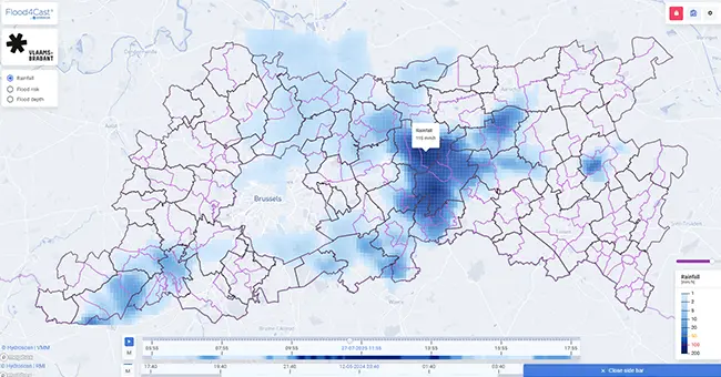
Rainfall view – With time slider to move through past, now, and forecas

Flood risk View – With time slider to move through past, now, and forecast
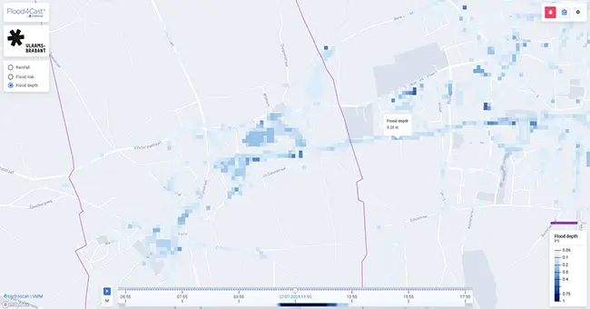
Flood risk depth view – With time slider to move through past, now, and forecast
6. Custom Alerts
Authorities define who receives alerts, under what conditions, how and when — fully compatible with established emergency protocols.

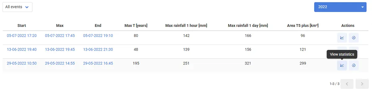
7. Historical Data & Simulation Exercises
All relevant events are archived and can be replayed for training, simulation exercises, and post-event analysis, helping refine protocols and continuously improve readiness.
Interested in an online demo? Any question we can help you with?
Ask for an online demo presentation or an initial exploratory talk. Contact us the way it suits you best.